Jarrard Gap Trail at Lake Winfield Scott to Jarrard Gap on the AT to Neels Gap on the AT
Date:
April 4, 2009
Trip Host:
Jeremy Landers
Location:
Appalachian Trail
Lake Winfield Scott Recreation Area
Lumpkin & Union Counties in Georgia
Cost:
Carry cash for fuel sharing & day use fees.
Difficulty:
Moderate
Length:
6.5 Miles Total 1 Miles Jarrard Gap Trail (Access Trail From Lake Winfield Scott) 5 Miles Jarrard Gap on the AT to Neel's Gap
0.5 Mile Neels Gap to Parking Area
Blaze:
White Rectangle (Appalachian Trail)
Blue ( Jarrard Gap Trail)
Departs From:
Quillans Corner Cheveron
Other locations can be arranged by contacting Jeremy
Departure Time:
8:00am Quillians Corner Chevron
Meals:
Lunch:
Bring a trail lunch or snacks
Supper: (Optional)
Weather permitting we will gather around a campfire (or grill) to cook out at Vogel State Park or Boggs Creek Campground. Bring a meat for the grill. Don't forget your plates, cups, hot choc mix, beverage, plasticware, etc. Jeremy will provide the campfire. In the event of bad weather we will dine at Creekside Cafe in Cleveland.
NOTE: The Vogel Visitors Center is closed for renovations. The store will NOT be open for us to purchase supplies etc.
Transportation:
POV's with carpooling, or drive on own. If you need transportation you can post an email to the hike group email list.
(Always be prepared to drive your own vehicle if necessary. If you carpool, fuel costs should be shared.)
GPS Info:
NA
USGS Quad:
Ranger District:
Hike
Schedule:
8:00 am Meet @ Quillians Corner Chevron.
8:05 am Depart Quillians Corner Chevron.
9:00 am Drop Vehicle at Byron Herbert Reese Parking Area
9:30 am Restroom break at Vogel State Park. NOTE: The general store will NOT be open for us to purchase supplies etc. due to renovations under way. However there is a very limited supply of a few things in the office behind the Visitors Center. M&Ms, firewood, newspapers, & a t shirt or two.
10:00 am Arrive at Lake Winfield Scott Recreation Area
The area is currently closed for the winter so I'm hoping to have somone shuttle us from Byron Herbert Reese Parking Area to the trail head.
10:15 am Meet at the vehicles for safety briefing.
10:30 am Depart on Jarrard Gap Trail.
11:15 am Jarrard Gap Trail dead ends into Appalachian Trail at Jarrard Gap.
11:20 Head North on the AT towards Neels Gap.
1:15 pm - Blood Mt. & Lunch.
1:45 pm Depart on trail Northward.
3:45 pm Reach Neels Gap. Restroom break & shop at Mountain Crossing's Outfitter's. This is a great place to buy boots & such.
4:15 pm Depart for parking area
4:30 pm Depart parking area for dinner location or home.
4:45 pm - Gather around campfire or grill for dinner* (Optional).
Return to Gainesville as you wish.
*Upon returning from the hike, those who wish to stay for fellowship are invited to join us at the around the campfire (weather permitting, in the event of bad weather we'll go to Creekside Deli in Cleveland) - this is optional and we always understand if you need to depart and return home - be sure and check with your driver as to what their plans will be if you are a rider.
All times are approximate and are subject to change without notice! Direction of travel is subject to change as well.
Trail Description:
• 0.0 Lake Winfield Scott.
•1.0 Jarrard Gap (3250 ft).
• 2.3 Woods Hole Shelter (3460 ft), privy 0.4 miles west on side trail. Water at mid-point on trail.
• 2.4 Bird Gap (3,650 ft). Freeman Trail bypasses Blood Mountain summit and leads 1.8 miles to Flatrock Gap.
• 2.7 Slaughter Creek Trail, blue-blazed to left leads 2.7 miles to Lake Winfield Scott Recreation Area (USFS). Stream at right turn is the last water before Neels Gap and is the water source for campsites ahead.
• 2.8 Slaughter Creek Campsite, eight tent pads built on sidehill.
• 3.6 Blood Mountain (4461 ft, highest point on the A.T. in Georgia). Blood Mountain Shelter with privy located on summit. Closest water is creek at A.T. and Slaughter Creek trail junction. Panoramic views in all directions.
• 5.0 Flatrock Gap (3440 ft), Trail to Byron Reece Memorial, west .6 mi. Parking; Freeman Trail bypasses Blood Mountain summit and leads 1.8 miles to Bird Gap.
• 6.0 Neels Gap (3125 ft), paved US 19/129 with parking at Byron Reese Memorial north on highway. Walasi-Yi Center has hiker supplies, equipment and hostel available on first come, first serve basis.From here we will either head back to the parking lot or up to Jeremy's campsite for dinner (Optional).
Trip Notes:
In Case Of Emergency Forms (ICE):
Last fall we started circulating new ICE forms for each hiker to fill out for emergency contact information. The only part of this form that is required to be completed is the personal contact info for each hiker. We think it would be wise to provide the medical information, but that is optional for each hiker. These forms and the envelope they will be sealed in are bright yellow. If you have not turned in a new ICE form, you will need to do so before you hike April 4th. You may contact Marsha or Jeremy to obtain a form. Please have these forms filled out before we meet to hike on April 4th. You can turn them in at the hike site, but it will be best to have them filled out before we gather to hike.
General
Notes:
Walk at your own pace! Try to walk with someone when possible and try to stay in sight or sound of the main group which means the lead hikers may need to slow or stop to let the rear hikers catch up. This is a good reason to carry a whistle on you at all times. Lead hikers should stop at all trail intersections to let everyone gather before moving forward.
If you need a potty break while on the trail, just let someone know you are leaving the trail for a few moments and have that person wait nearby until you return. If you should feel ill or become weak while hiking, let Jeremy or Marsha know immediately. Do not push yourself forward on the trail under adverse conditions. One of us will work with you to maintain your safety. If you have any medical concerns that need to be known, be certain a hiking partner or Jeremy/Marsha know about any issues that could require immediate attention.
Carpoolers should share the cost of fuel when returning to their base location.
If you have any questions regarding the logistics for this hike, please contact Jeremy Landers. If you are signing up to hike or have transportation issues, contact Jeremy Landers. More info on our hiking plans can be found at: www.LandersStudions.com/gechike
PLEASE - DO NOT CONTACT THE CHURCH OFFICE REGARDING THE HIKES. THE CHURCH OFFICE DOES NOT HANDLE OUR PLANS NOR ROSTER FOR THIS ACTIVITY. CONTACT JEREMY OR MARSHA DIRECTLY.
HIKE AT YOUR OWN PACE - BUT HIKE WITH A PARTNER OR IN SIGHT OR SOUND OF YOUR GROUP FOR SAFETY.
Links & Ref.
Photos
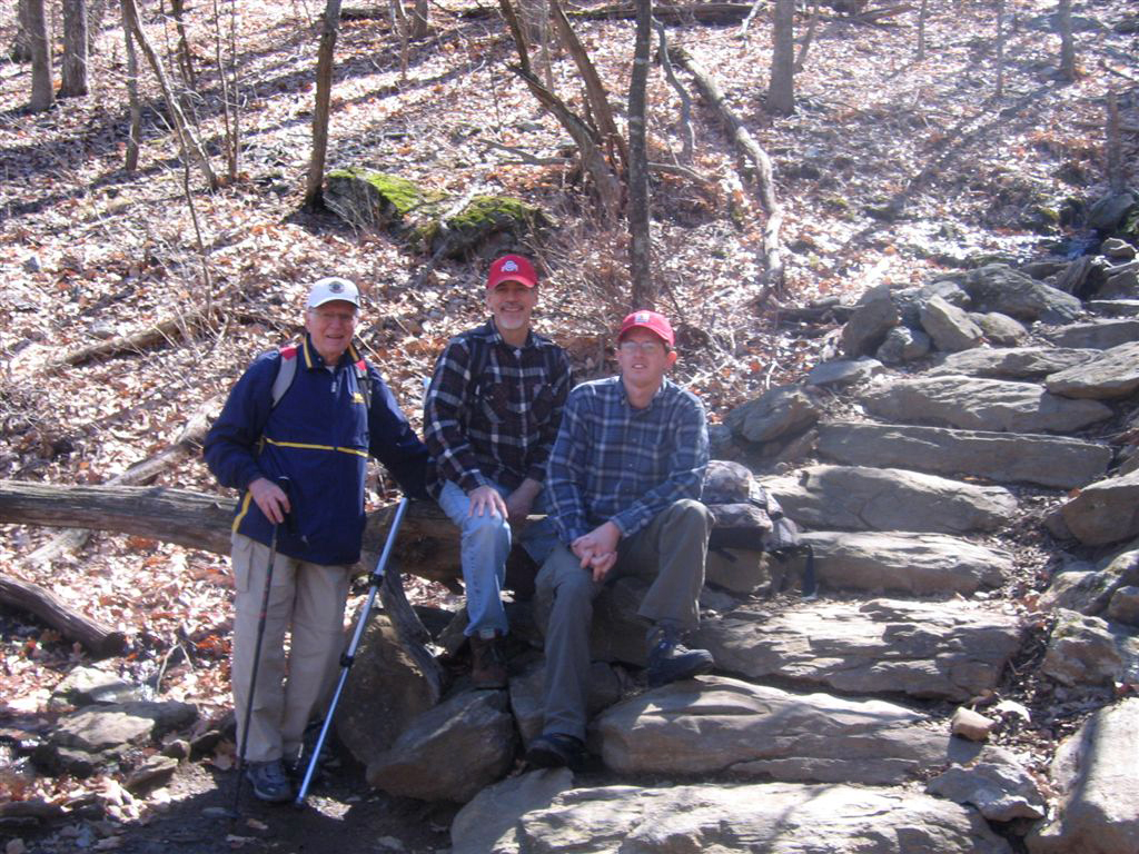
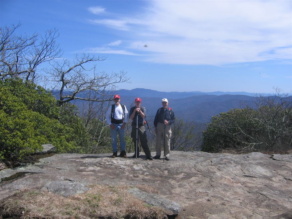
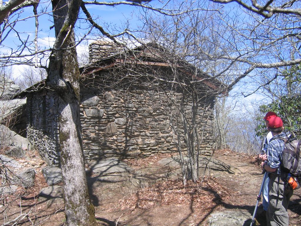
Photos By John Hunt
John, Tom, Jeremy at Slaughter Creek
Tom, Jeremy, John atop Blood Mt.
Blood Mountain Shelter
Video Clip By Jeremy Landers
Map
http://www.georgiahikes.com/maps/bin/AT_woody_to_neels_new.jpg
Includes Elevations
Directions:
From Gainesville
Take Hwy 129 North to Cleveland Georgia. Go through the downtown square continue on Hwy 129 North to the Byron Herbert Reese Parking Area. The parking area will be located 1/4 mile North of Neels Gap on the left.
With just three hikers we started a little earlier than planned as we were all early getting to Quillians Corner. We were on the trail by 9:30am. Our day began with a light breeze and about 45 degrees. The hike started at Lake Winfield Scott in Suches Ga. where we climed the 1.2 Jarrard Gap Trail which is an access trail to the Appalachian Trail at Jarrard Gap. Just under an hour later the trail intersects the AT. From here we headed North on the AT towards Blood Mt. passing quite a few hikers along the way. With birds chirping and a steady wind along the ridgeline we passed several side trails including the Woods Hole Shelter Trail, Freeman Trail which bypasses the summit of Blood Mt. from Bird Gap on the South side to Flatrock Gap on the North side, we also passed the Slaughter creek Trail which leads 2.7 miles back to Lake Winfield Scott. Just past the Slaughter Creek Trail there are some nice campsites to the right of the trail. From here the summit of Blood Mt. is only about 20 min. away. Upon cresting Blood Mt. we were greeted with the clearest view any of us had seen up there with a panoramic views in all directions. We could even make out Stone Mountain near Atlanta. We ate our lunch with a westward view then headed down the quite steep descent on the Northern side of the mountain. Along the way we actually encountered two children hiking barefoot about 2 miles into their hike. Upon reaching Flatrock Gap we opted for the Byron Reece Trail back to the parking lot and Jeremy's Truck. What a great way to spend the day!
Please take a moment to read the Participation Guidlines prior to hiking with the Grace Church Hike Group.
Additional Info For All Hikes Information provided by Marsha Conner
ICE INFO
(In Case Of Emergency)
We are now carrying ICE forms with us for safety. The hike planner will
be responsible for being sure these cards are on the trail. A form in a
sealed yellow envelope with critical contact and medical data on each
hiker will be available in case of emergencies. You are required to fill
out the emergency contact information however the medical information
is optional, should an emergency arise, this data would go with you for
medical treatment and provide contact information for your relatives
and medical information at the ER that should be known. Many of us have
ICE phone numbers in our cell phones, but our cell phones may not work
in some wilderness areas.
WHAT TO CARRY
You should be self-sufficient on the trail. Do not plan to borrow items you
do not have from people hiking with you. They may not have what you need
or they may need it for themselves. Carefully look over the trail description and
map before going, ask questions, and make sure that you are physically able to
handle the terrain, the temperatures, the possible wetness, and the other
interesting things that might happen to us while on the trail! As always we
set our hiking pace to accomadate everyone. So don't think you'll be too slow.
Jeremy & Marsha are always willing to help you to be trail ready.
1. Daypack
2. Water/Fluid Supplies
3. Food/Snack Supplies
4. Cash and Photo ID (ID should be on your person at all times)
5. Other Outdoor Supplies
6. 4 AA Batteries to use in our walkie talkies.
1. Packs:
a. Plan and pack for medical emergencies including
blisters, bug bites, allergies, cuts, etc.
b. At least one snake bite kit (Sawyer style) should be
with the group (sold in most sporting goods depts).
c. Weather change needs such as poncho, emergency
blanket, cap, gloves, wind jacket, etc.
d. Cell phone (in case it might work) and other
items important to you for personal safety or comfort
2. Water/Fluid Supplies
a. Plan on carrying a cooler in your vehicle with ice to keep
food and fluids cold throughout the trip
b. Carry enough fluid with you for the designated trail hike
c. Do Not Drink Water From Streams - most mountain
water is no longer safe to drink as they may contain
protozoan imps and make you very sick
3. Food/Snack Supplies
a. Short hikes may only require a light snack
on the trail (1-2 miles) - plan accordingly
b. Longer hikes usually require a moderate
snack on the trail (3-4 miles) - plan accordingly
c. Remember that your appetite is enhanced by
being outdoors and doing physical activity
4. Cash and ID
a. Carry bills in different increments especially "ones"
for park entrance fees and incidentals - each
person is responsible for their own fees and should
share any group cost for parking and fuel
b. The cost of fule is to be shared between driver and
passengers.
c. For your safety, have your ID with you on the trail at
all times.
d. Do not leave valuables in your parked car which you
cannot afford to have stolen!
5. Other Outdoor Supplies
a. Camera, Flash Card(s) or film
b. Binoculars
c. Sun hat
d. Knife and compass
e. Extra socks if prone to blisters
f. Bug spray
g. Sting relief especially if you are
allergic to insect stings
h. Hiking pole or sticks
i. Sweat towel and/or bandana
j. Large Pepper Spray (for animal attacks and personal protection)
6. Hunting Season
Remember your Blaze Orange During Hunting Seasons.
UPON RETURNING HOME
1. Critical - Shower and check your body - CAREFULLY -
for ticks (if a tick has attached itself to your skin, do
not crush its body while removing it, but lift it away
from your skin and pull out by the legs - treat the area
properly and watch for any redness - if redness appears
seek medical attention promptly)
2. Clean and treat any wounded areas of your body -
use ice for first 24-48 hours on joint/muscle injuries
and heat as swelling subsides
3. Consider keeping a log of your hiking experiences and
write your story in a journal while memories are fresh
4. Develop pictures and share copies with your hikers
GENERAL GUIDELINES TO REMEMBER
1. Leave pets at home if hiking with a group. More Info
2. Keep groups on the trail to no more than 4-6 together
3. Walk single file in the middle of the trail
4. Step to the side of the trail as you go downhill
to allow hikers going uphill to have the right of way
5. Do not wade with your boots on unless necessary
Wet socks and shoes can create immediate blisters
6. Swift water can cause you to lose your footing in
6-12 inches of water so do not be fooled that you
can wade without danger across a stream
7. Snakebites are a critical concern to hikers
THINK before putting your hands and feet anywhere
that might be a place of hiding for a snake:
a. Step on the top of logs - not over them
b. Use your hiking pole to check on the backside
of logs and rocks before sitting down
c. Stay on the trail where visibility is better
8. Read the many different theories on protection
from bears and other wildlife - bears are most
aggressive when protecting their cubs and stay
near water and food sources frequently - bears
do not "growl" but will make a "grunting" noise
to let you know they see you when you may not
see them - stop, back away slowly, and move
back down the trail without hesitation - do not
mistake a "grunting" noise for random woods noise
on a trail as it may only be made one time to give
you one chance to back away. Carry a large pepper spray.
9. Let members of your hiking group know your intentions
in case you decide to return to the parking lot or leave
for the day.
10. Remember that the GEC Open Hike each month will
have a mixed skill level and cooperation as a team is needed.
The monthly planner has volunteered to set up the hike
and there may be slight differences with each hike.
There is room for both the scenic hiker and the extreme
hiker with good communication and proper planning.