|
 |
 |
 |
|
 |
Hike Info Page
|
|
|
|
|
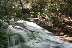
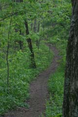
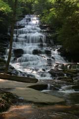
The trails / waterfalls for the May hike are located along the Tallulah River Road (Forest Service Road #70) in Rabun/ Towns Counties of Georgia and Clay County North Carolina (FS 70 becomes 56 in NC). This trip has been designed so that you can hike a few or all of the trails. We will begin our day with the Beech Creek Trail, the longest of the trails a 4.5 mile (all mileage is round trip) trail which leads to Bull Cove Falls and High Falls. This trail is considered Moderate to Strenuous. Our next stop will be Denton Branch Falls a 25ft cascade and 0.6 mile easy walk on an old road bed, followed by a 1.2 mile difficult steep hike to Flat Branch Falls with a 100 foot cascade. We will conclude our day on the Coleman River Trail, a highly scenic 2 mile trail that originates at a fishing sign and follows the Coleman River upstream. One of the largest white pines in Georgia can be found along this trail. It circumference is over 10 feet. The trail continues on to a waterfall.
Bring a pack lunch, plenty of water, rain gear, camera, snacks, first aid supplies, bug repellant, sunscreen, hat, and whatever you may need as we will be gone all day. We will eat dinner on our way back to Gainesville.
Total Length of combined hikes 8.3 Miles.
We will carpool departing from the Grace Center (422 Brenau Ave. Gainesville, GA) at 8:30am Saturday May 13, 2006
For more information contact Jeremy Landers at 770-861-8175
For photos, trail descriptions, GPS coordinates, maps & a list of other up coming hikes visit the Hike group’s web page at www.LandersStudios.com/gechike.
To sign up for this trip make a reservation with the church office at 770-536-0126 |
|
 |
|
|
|
|
|
|
| Trip: |
Coleman River Trail |
| Date: |
May 13, 2006 |
| Trip Host: |
Jeremy Landers |
| Location: |
Rabun County |
| Difficulty: |
Easy to Moderate |
| Length: |
2 Miles Round Trip |
| Departs From: |
The Grace Center |
| Departure Time: |
8:30AM |
| Meals: |
Bring a pack lunch and snacks for the day, Dinner out on our way home. |
| Transportation: |
Carpool |
| GPS Info: |
NA |
| USGS Quad: |
Hightower Bald |
| Ranger District: |
Tallulah |
| Trial Description: |
A highly scenic trail that originates at a fishing sign and follows Coleman River upstream. At 0.2 miles can be found one of the largest white pines in Georgia. It circumference is over 10 feet. The trail continues on to mile 0.8 where a waterfall can be found. |
| Notes: |
A great beginners trip. Scenic and easy. A small cave can be found a short distance beyond the campsite. There is only one primitive campsite, so make sure you have alternative plans in case someone beats you to it. There's also a geocache on this trail for those interested. |
| Links & Ref. |
Trail Data From GeorgiaHikes.com
2 Trail Reports
http://georgiatrails.com/trails/coleman.html |
| Photos |
NA |
| Map |
http://www.georgiahikes.com/maps/bin/coleman_river_trail.gif
Download PDF Road Map |
| Directions: |
Directions From GeorgiaHikes.com |
| Reservations: |
Yes, Make Reservation with church office |
|
|
|
|
|
| Trip: |
Flat Branch Falls |
| Date: |
May 13, 2006 |
| Trip Host: |
Jeremy Landers |
| Location: |
Towns County |
| Difficulty: |
Difficult |
| Length: |
0.6 Round Trip |
| Departs From: |
The Grace Center |
| Departure Time: |
8:30AM |
| Meals: |
Bring a pack lunch and snacks for the day, Dinner out on our way home. |
| Transportation: |
Carpool |
| GPS Info: |
NA |
| USGS Quad: |
NA |
| Ranger District: |
|
| Trial Description: |
To reach this waterfall, follow the worn path at the southeast corner of the bridge. The first 200 feet is quite steep! Cross the creek at the first convenient spot, then find your way up the steep mountainside to the base of the falls. |
| Notes: |
A large waterfall with a 100 foot cascade. |
| Links & Ref. |
Waterfalls of the Southern Appalachians by Brian A. Boyd, Third Edition |
| Photos |
NA |
| Map |
Download PDF Road Map |
| Directions: |
|
| Reservations: |
Yes, Make Reservation with church office |
|
|
|
|
|
| Trip: |
Denton Branch Falls |
| Date: |
May 13, 2006 |
| Trip Host: |
Jeremy Landers |
| Location: |
Towns County, Ga
Southern Nantahala Wilderness |
| Difficulty: |
Easy |
| Length: |
0.3 |
| Departs From: |
The Grace Center |
| Departure Time: |
8:30AM |
| Meals: |
Bring a pack lunch and snacks for the day, Dinner out on our way home. |
| Transportation: |
Carpool |
| GPS Info: |
Falls - N34º 59.142 W83º 33.00' |
| USGS Quad: |
|
| Ranger District: |
|
| Trial Description: |
An easy walk mostly on an old roadbed. |
| Notes: |
Waterfall has a 25ft. cascade. |
| Links & Ref. |
Waterfalls of the Southern Appalachians by Brian A. Boyd, Third Edition |
| Photos |
http://www.jjanthony.com/waterfalls/falls/dentonbranchfalls.html |
| Map |
Download PDF Road Map |
| Directions: |
|
| Reservations: |
Yes, Make Reservation with church office |
|
|
|
|
|
| Trip: |
Falls on Beech Creek / Beech Creek Trail |
| Date: |
May 13, 2006 |
| Trip Host: |
Jeremy Landers |
| Location: |
Clay County, NC
Southern Nantahala Wilderness |
| Difficulty: |
Moderate to Strenuous |
| Length: |
4.5 miles In and back or
7 miles point to point (optional if the group wants to do this) |
| Departs From: |
The Grace Center |
| Departure Time: |
8:30AM |
| Meals: |
Bring a pack lunch and snacks for the day, Dinner out on our way home. |
| Transportation: |
Carpool |
| GPS Info: |
NA |
| USGS Quad: |
Hightower Bald, Rainbow Springs |
| Ranger District: |
Tusquitee Ranger District |
| Trial Description: |
This trail can be hiked either as an in & out to the waterfalls as a 4.5 mile hike or as a 7 mile point to point hike. The decision will be up to the group of hikers present.
4.5 Mile Version
Take trail #378 to the east of Tallulah River Road. The path climbs several hundred feet over a high ridge before descending to Beech Creek at a half mile. The trail crosses the creek and shortly intersects a logging road. Turn left onto this roadbed and proceed half a mile to Bull Cove Creek. Cross the creek and follow the path ups stream, finding your way through the thick underbrush to Bull Cove Falls. This 40 foot falls is only about 100 yards from the Beech Creek Trail. Past Bull Cove Creek the trail climbs slowly, soon crossing Beech Creek before continuing the climb up into Beech Creek Gorge. Bear Creek Falls is located about 0.4 mile beyond the Beech Creek Crossing. Bear Creek cascades down a long, rock face before crossing the trail and dropping into Beech Creek. Bear Creek Falls is a series of high water slides, some of which are hidden high above the trail . Keep a sharp eye out on this portion of trail, as numerous small cascades spill down from the mountain. At about 2 miles the remains of a corundum mine can be seen beside the trail. This begins a series of switchbacks and the trail climbs steeply. Proceed to the beginning of the second switchback to the left and take the side trail that drops back down to Beech Creek and High Falls. Sit a spell, enjoy the view and then head back.
7 Mile Version Click link below
Trail Description (7 mile version) From GeorgiaHikes.com
|
| Notes: |
|
| Links & Ref. |
Waterfalls of the Southern Appalachians by Brian A. Boyd, Third Edition
Trail Description (7 mile version) From GeorgiaHikes.com
2 Trail Report From GeorgiaHikes.com |
| Photos |
Bull Cove Falls
High Falls |
| Map |
Download PDF Road Map |
| Directions: |
|
| Reservations: |
Yes, Make Reservation with church office |
|
|
|
|
|
|
|
|
|